Basin
A basin is a large underground geologic area where oil and natural gas formed and became trapped over millions of years. Texas sits over three major producing basins: the Permian Basin in West Texas, the Eagle Ford Shale in South Texas, and the Haynesville Shale in East Texas.
For a mineral owner, your basin is one of the most important facts about your minerals. It shapes what operators may be willing to pay, how active drilling is likely to be, and what royalty income your land may generate over time.

What This Means for Mineral Owners
The basin or producing region your minerals sit in is one of the biggest factors influencing their value. Mineral rights in a highly active area like the core of the Permian often command higher lease bonuses, stronger royalty terms, and more drilling interest than similar acreage in an inactive or unproven area. Two mineral owners with identical 80-acre tracts can have very different futures depending on which basin they own in.
Knowing your basin helps you set realistic expectations: what kind of well you might see drilled, what nearby production looks like, and what a fair lease offer should be. In a highly competitive core area, a high per-acre bonus may be reasonable. In an area with little current activity, the same offer should be reviewed carefully.
How a Basin Forms
A sedimentary basin forms over geological time when a section of the Earth's crust gradually sinks. As it sinks, layers of sediment (sand, silt, mud, and organic matter) settle in and eventually compact into rock. Under heat and pressure, the organic matter slowly transforms into oil and natural gas.
For a petroleum system to produce commercial volumes of oil and gas, several geologic elements usually need to be present and arranged correctly, including source rock, reservoir rock, seal rock, migration pathways, and proper timing.
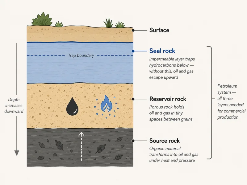
Source rock
Rock rich in buried organic material. Under the right conditions of heat and pressure, this rock generates hydrocarbons over millions of years. Shales and certain limestones often serve as source rocks.
Reservoir rock
Porous rock that can hold oil and gas in the tiny spaces between its grains. Sandstones, certain limestones, and fractured shales make good reservoir rocks because they have enough porosity and permeability to hold and release hydrocarbons.
Seal rock
A layer of impermeable rock above the reservoir that traps the oil and gas in place. Without a seal, the hydrocarbons would migrate upward and escape over time. Salt, dense shale, and tight limestone often act as seal rocks.
When the key elements of a petroleum system are present and properly arranged, the result may be a hydrocarbon system that can be drilled and produced commercially. When a key element is missing, such as source rock, reservoir quality, seal, migration pathway, timing, or sufficient pressure, a basin may exist geologically but may not produce commercial quantities of oil or gas.
Modern technology has expanded what counts as a productive basin. Hydraulic fracturing and horizontal drilling now allow operators to produce from tight, low-permeability rock that older vertical wells could not. This is why basins like the Permian, once considered mature in the 1990s, are now among the most productive in the world.
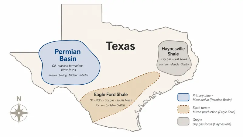
Major Texas Basins
Texas is home to some of the largest and most productive basins in North America. Many Texas mineral owners hold acreage in or near major producing regions such as the following.
Permian Basin (West Texas and southeastern New Mexico)
One of the most active oil and gas basins in the United States and the largest oil-producing basin in the country. The Permian contains multiple stacked productive zones, meaning operators may be able to drill separate wells into different formations beneath the same acreage over time.
Owners in the Permian typically see strong lease bonuses, competitive royalty rates, and consistent drilling activity. Counties such as Reeves, Loving, Midland, and Martin sit in the heart of the Permian.
Eagle Ford Shale (South Texas)
A major shale play and producing formation that produces oil, natural gas liquids, and dry gas depending on depth, location, and thermal maturity. The Eagle Ford runs through counties like Karnes, La Salle, DeWitt, and McMullen. Owners in the Eagle Ford have generally seen strong development since modern horizontal drilling began there around 2009.
Haynesville Shale (East Texas and northwest Louisiana)
A major dry gas shale play with high-pressure, gas-rich formations. Counties like Harrison, Panola, and Shelby produce significant Haynesville gas. Owners in Haynesville areas commonly see gas-focused royalty income, often with limited liquids value compared with wetter oil or NGL-rich plays.
What basin location means for your royalty
The basin, play, and specific location within that producing region can shape what your royalty looks like, what your gas or oil may be worth, and how likely drilling activity is to reach your land.
How Basin Activity Affects Your Royalty Income
The basin your minerals sit in influences your royalty income through several mechanisms.
Lease bonus and royalty rate
Active basins with proven economics see competitive bidding for acreage. Lease bonuses in core areas of the Permian can vary widely depending on county, timing, commodity prices, operator competition, title quality, depth rights, and lease terms, with some competitive leases reaching strong royalty rates. Acreage in an unproven or inactive basin typically commands far less.
Drilling activity
Operators concentrate capital in basins with strong economics. If you own minerals in an active basin or producing region, you may be more likely to see drilling activity after leasing, but timing still depends on operator plans, commodity prices, lease terms, surface constraints, title, and infrastructure. In inactive basins, leases can sit for years without drilling.
Production rates and royalty volume
Wells in different basins produce different volumes. Modern horizontal wells in core areas can produce far more in early months than older vertical wells in marginal areas, but actual rates vary widely by formation, operator, completion design, pressure, location, and market conditions. Your royalty share of those volumes is what shows up on your check.
Long-term sustainability
Some basins have decades of remaining productive life ahead of them, supported by improving technology, stacked plays, infrastructure, and continued operator investment.
For owners evaluating their minerals, Mineral View's Lease Report shows your specific lease's production data and operator activity, and the MVestimate projects six-year royalty income based on that lease-level data.
Basin vs Oil Field: What's the Difference?
Mineral owners often see both "basin" and "oil field" referenced in lease documents, royalty statements, and operator communications. They describe different scales.
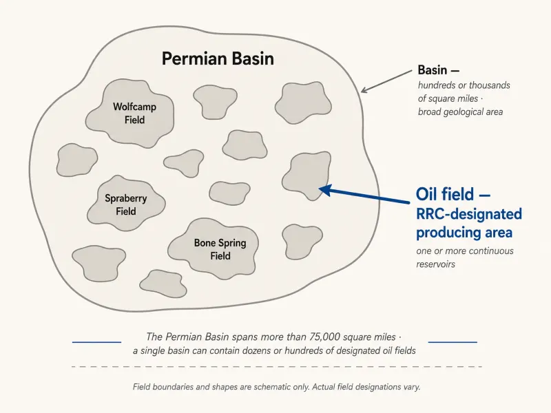
- A basin is a large geological area, typically hundreds or thousands of square miles, defined by its overall geological structure. The Permian Basin, for example, spans more than 75,000 square miles across West Texas and New Mexico.
- An oil field is a Railroad Commission-designated geographic area where wells produce from one or more continuous reservoirs. A single field may include multiple reservoirs at different depths. A single basin can contain dozens or hundreds of designated oil fields.
In practice, your minerals sit in one basin and may sit in one specific designated oil field within that basin. The basin tells you the broad geological context, while the field, formation, and lease-level data help identify the specific producing area or reservoir tied to your minerals.
A Real-World Scenario
Example: Carlos's Wolfcamp acreage in Reeves County
Carlos owns mineral rights on a 240-acre tract in Reeves County, Texas, in the heart of the Permian Basin. The minerals came down through his family from his great-grandfather, who acquired the land in the 1920s.
For most of the 20th century, the minerals produced modest oil revenue from older vertical wells, then went mostly dormant by the 1990s as the vertical-well economics played out. The family assumed the productive life of the minerals was largely behind them.
Beginning around 2015, horizontal drilling and hydraulic fracturing reactivated the Permian Basin, including the area covering Carlos's tract. An operator approached the family with a lease offer in 2020: $7,500 per net mineral acre with a 25 percent royalty rate. The same minerals that had been generating a few hundred dollars per year in the 2000s suddenly carried a significant lease bonus and the prospect of substantial royalty income from new horizontal wells.
By 2023, the operator had drilled two horizontal wells on or affecting the leasehold, with development targeting stacked Permian formations in the area. Carlos's royalty income from those wells in their first full year of production exceeded what the family had earned from the minerals in the previous twenty years combined.
The lesson: the underlying geology was largely the same in 1995 as it was in 2020. What changed was the technology, commodity economics, infrastructure, and operator strategy that allowed more of the resource to be produced economically. For mineral owners, the basin sets the long-term potential, even if it takes new technology to access it.
What to Check
Confirm which basin your minerals sit in
Most mineral owners know roughly where their land is, but the basin designation may not be on their deed. A landman, geologist, operator records, public Railroad Commission of Texas data, or Mineral View's Lease Report may help confirm the basin, play, field, and producing formation associated with your tract.
Compare nearby leases and production
Looking at nearby wells in the same formation, field, and producing trend is usually more useful than comparing all wells across the same broad basin. Wells within a few miles of your tract, in the same formation, are the most relevant reference points.
Watch for basin-level activity trends
Basins go through cycles. A basin or producing region with low drilling activity today may become more active when commodity prices rise, technology improves, infrastructure expands, or operators renew interest, as parts of the Permian did during the modern horizontal drilling boom. Knowing the basin trends helps you set expectations for the long term.
Important
Mineral View can help you understand basin context, production activity, and operator behavior for your minerals. For questions about your specific basin designation, lease terms, or how to evaluate offers in your area, consult a qualified landman or Texas oil and gas attorney.
Common Questions
The county where your land sits is the easiest starting point. Reeves, Loving, Midland, and Martin counties are commonly associated with the Permian Basin. Karnes, La Salle, and DeWitt counties are commonly associated with the Eagle Ford Shale trend. Harrison, Panola, and Shelby counties are commonly associated with the Haynesville/Bossier Shale area. A landman or the Railroad Commission of Texas can confirm your specific basin if it is not immediately obvious from the county.
No. The basin sets the potential, but actual income depends on the specific lease, the wells drilled on or near your acreage, current commodity prices, and your royalty rate. Owners in active basins generally fare better than owners in inactive ones, but two owners in the same basin can have very different incomes depending on the specifics of their leases and the wells that get drilled.
Yes. Basins and producing regions go through long cycles. New technology, such as horizontal drilling and hydraulic fracturing, can revive areas once considered mature or less economic. Commodity price swings can dramatically change drilling activity. The basin's geological character changes slowly over geologic time, but the economics of producing from it can change significantly because of technology, commodity prices, infrastructure, regulations, and operator strategy.