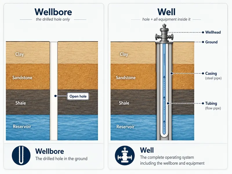
Wellbore
A wellbore is the hole drilled into the earth to reach an oil or gas reservoir or formation. It is the physical void the drill bit creates as it cuts through layers of rock toward the target formation.
The wellbore is the hole itself, nothing more. Once drilling is complete, the wellbore is lined with steel casing, cemented in place, and outfitted with equipment to transform it into a functioning well. The wellbore is the starting point for creating a functioning well.
Owner-First View
A wellbore on your property is the first sign that an operator is developing your minerals. Every producing well begins with a wellbore — and every royalty payment you receive traces back to a wellbore that reached the right formation at the right depth. Understanding what a wellbore is, how it is drilled, and how its path is measured helps you read operator notices, RRC filings, and production data with accuracy.
How a Wellbore Is Drilled
Drilling a wellbore is a staged process. A drilling rig rotates a drill bit through layers of rock, advancing toward the target formation. As the drill bit cuts deeper, drilling fluid, often called mud, is pumped down through the drill pipe and bit, then circulates back up the space between the drill pipe and the wellbore wall.
Drilling fluid does three things specific to the wellbore: it maintains pressure inside the hole to prevent the walls from collapsing, it cools and lubricates the drill bit as it cuts, and it carries rock cuttings from the bottom of the wellbore back to the surface.
Wellbores are drilled in stages, with each section having a progressively smaller diameter. The surface section is the widest, typically drilled to a few hundred feet, followed by one or more intermediate sections of progressively narrower diameter. The final production section is the narrowest, drilled all the way to the target formation.
Drilling ends when the wellbore reaches total depth, the point at which the target formation has been reached. At that stage, the wellbore is complete. What happens next — running casing, cementing, perforating, installing equipment — is the process of building a well inside the hole the wellbore created.
Wellbore Depth and Measurements
Two measurements describe the depth of a wellbore, and they are not the same, particularly for horizontal wellbores.
True Vertical Depth (TVD)
TVD is the vertical distance from the surface to the deepest point of the wellbore, measured along a straight line, regardless of the wellbore's actual path. For a vertical wellbore, TVD is essentially equal to the length of the hole. For a horizontal wellbore that curves and runs laterally, TVD measures how deep the formation is, but it does not account for how far the wellbore travels horizontally.
Measured Depth (MD)
MD is the total length of the wellbore path, measured along every curve and turn from surface to total depth, including horizontal sections. For a horizontal wellbore, MD is significantly greater than TVD. A wellbore with a TVD of 9,500 feet may have a measured depth of 18,000 feet or more once the lateral section is included.
Why the difference matters for mineral owners
Both measurements, TVD and MD, appear in RRC filings, completion reports, and well data. When a report shows a TVD of 9,500 feet and an MD of 18,200 feet, it means the wellbore went 9,500 feet straight down and then ran 8,700 feet horizontally through the formation. Understanding this helps when reading the technical documents that describe what the operator drilled on your lease.
If you own oil and gas leases in Texas, Mineral View's Well Report gives you access to complete well details, including True Vertical Depth (TVD) and Measured Depth (MD).
| TVD | MD | |
|---|---|---|
| What it measures | Vertical distance from surface to deepest point | Total length of the wellbore path |
| For vertical wellbores | Equal to MD | Equal to TVD |
| For horizontal wellbores | Depth of the formation only | Much greater — includes the full lateral length |
| Where it appears | RRC filings, completion reports, well data | Same |
Vertical, Directional, and Horizontal Wellbores
Not all wellbores follow a straight vertical path. The path a wellbore takes is determined by the geology of the target formation and the operator's development plan.
Vertical Wellbore
Drilled straight down from the surface to the target formation. Common in older Texas fields and conventional reservoirs where oil or gas pools directly beneath the surface location. TVD and MD are approximately equal.
Directional Wellbore
Drilled at an angle rather than straight down. Used to reach a target that is not directly below the surface location, or to access multiple zones from a single surface pad. The wellbore deviates from vertical but does not run fully horizontal.
Horizontal Wellbore
The most common type in modern Texas oil and gas development. The wellbore is drilled vertically to a certain depth (called the kickoff point) then gradually curved until it runs horizontally through the target formation. The horizontal section, called the lateral, can extend 5,000 to 15,000 feet or more through the rock. Horizontal wellbores are common in tight formations like the Permian Basin and Eagle Ford because a long lateral exposes more of the formation to production than a vertical wellbore.
| Vertical | Directional | Horizontal | |
|---|---|---|---|
| Path | Straight down | Angled toward a target | Vertical then turns horizontal |
| TVD vs MD | Equal | Close | MD much greater than TVD |
| Lateral length | None | Limited | 5,000–15,000+ feet |
| Common use | Conventional reservoirs | Offset targets, multi-zone access | Tight formations — Permian, Eagle Ford |
| Formation exposure | One point | Limited section | Long horizontal section through the reservoir |
Directional Surveys: Mapping the Wellbore Underground
Because a wellbore cannot be seen once it is drilled, operators use directional surveys to precisely map the wellbore's path underground. Survey tools are run through the wellbore at regular intervals during drilling, measuring two things at each depth: inclination (the angle of the wellbore from vertical) and azimuth (the compass direction the wellbore is pointing).
These measurements are compiled into a directional survey, a detailed record of the wellbore's three-dimensional path from surface to total depth. For horizontal wells, the survey shows the kickoff point, the wellbore's curve into the lateral section, and where the lateral is located within the formation.
Directional surveys are filed with the Railroad Commission of Texas and become part of the public record for each wellbore. They are among the most precise documents describing what an operator drilled beneath a mineral owner's property.
Why Mineral Owners Should Care
The wellbore is not just a technical detail, it directly affects which formations are producing beneath your lease, how deep the operator reached, and what data is on record about development activity on your property.
-
The wellbore's path determines which formation is producing.
Texas leases can cover multiple formations at different depths. The wellbore's trajectory and total depth determine what the operator was targeting and whether they reached it. If a second wellbore is drilled targeting a different formation, it may produce under different lease terms or pooling arrangements. The directional survey is the record that proves which formation was actually penetrated.
-
Wellbore stability during drilling affects whether production ever begins.
Before a well is constructed inside it, the open wellbore must remain stable. In unstable formations, wellbore walls can collapse, and formation fluids may enter the well unexpectedly, leading to wellbore instability or kicks.
A wellbore that cannot be stabilized during drilling may be abandoned before it ever reaches the target formation, which means no production and no royalties from that drilling attempt.
-
Multiple wellbores may be drilled on one lease, sometimes from the same surface pad.
A single lease may support multiple wellbores, drilled from the same surface pad or different locations across the acreage. Each wellbore has its own path, its own target interval, and its own API number.
More wellbores on your lease generally means more production, but it also means more filings, more activity to track, and more data to review.
-
Wellbore data is public and accessible.
Every wellbore in Texas has a unique API number assigned by the Railroad Commission at the time the drilling permit is issued. The API number is a ten-digit identifier structured in three parts: the first two digits are the state code (42 for Texas, though the Railroad Commission typically omits this from its own documents), the next three digits identify the county where the wellbore is located, and the final five digits are the unique number assigned to that specific wellbore.
Directional surveys, drilling reports, and depth records are filed under the API number and are publicly available. These documents describe the wellbore's physical path through the subsurface, independent of any production data.
Because the API number is assigned at the wellbore level (not the lease level) a single oil lease with multiple wellbores will have a separate API number for each one. Gas leases work differently: each gas lease has only one wellbore and therefore only one API number.
Where the Wellbore Appears in the Lease Lifecycle
1. Drilling Permit
Before drilling begins, the operator files a W-1 drilling permit with the Railroad Commission of Texas. This document describes the well the operator plans to drill, its surface location, target formation, proposed depth, and intended wellbore direction.
The API number is assigned to the wellbore at this stage. It is the first public record that a new well is coming to a specific lease.
2. Drilling
The wellbore is physically created. The drill bit advances through the subsurface, guided by directional tools that measure inclination and azimuth at regular intervals. Drilling fluid keeps the open hole stable and carries cuttings to the surface.
This stage ends when the wellbore reaches total depth at the target formation. At that point, the wellbore itself is complete.
3. Well Construction and Completion
Once the wellbore reaches total depth, the wellbore's job is done, it is now a stable hole in the ground. The construction phase begins: steel casing is run into the hole, cement is pumped into the space between the casing and the wellbore wall, and the well is built inside the hole the wellbore created.
The wellbore's path and the formations it penetrated determine where perforations will be placed during completion.
4. Production
Oil and gas flow from the target formation into the wellbore and travel to the surface through the well built inside it. The wellbore's depth, trajectory, and the formation it penetrated directly determine what is produced and at what volumes.
5. Workover
If production declines or a problem develops, the operator may perform a workover, remedial work carried out inside the existing wellbore. The wellbore itself remains the fixed physical structure within which all remedial activity takes place.
6. Plug and Abandon
At the end of the well's productive life, the wellbore is permanently sealed with cement plugs placed at strategic depths to isolate each formation the wellbore penetrated and prevent fluid migration between them.
A plugging report is filed with the Railroad Commission. The wellbore remains underground permanently, sealed and inactive, but never removed.
A Real-World Scenario
Maria owns mineral rights in Reeves County, Texas. Her operator drilled a horizontal wellbore targeting the Wolfcamp A formation. The wellbore was drilled to a TVD of approximately 9,500 feet — the depth of the Wolfcamp A — before curving horizontal and extending 9,000 feet laterally through the formation. The total measured depth was just over 18,500 feet.
A directional survey filed with the Railroad Commission documented the exact three-dimensional path of the wellbore: where it kicked off vertical, the arc of its curve, and the precise position of the 9,000-foot lateral within the Wolfcamp A interval.
Every barrel of oil Maria receives royalties on came from that specific formation — reached only because the wellbore was drilled to the right depth and turned in the right direction.
What to Check
-
Find the API number for any wellbore on your property.
The API number is the permanent identifier assigned to every wellbore in Texas by the Railroad Commission at the time the drilling permit is issued. It appears on drilling permits, directional surveys, and all subsequent RRC filings related to that wellbore.
The number has ten digits, but when searching the RRC website for oil and gas records, enter it without the first two digits (the state code 42). The RRC search expects the eight-digit version; including the state code prefix will return no results.
Once you have the correct number, every public document about that wellbore is searchable directly on the RRC website.
Mineral View's Well Report is organized around the API number. It shows wellbore construction details, formation targets, TVD, measured depth, and a complete set of RRC filings, including directional surveys, all in one place.
-
Check for additional wells being planned on your lease.
Each new well begins with a drilling permit filing. Mineral View's Lease Activity tracks daily RRC filings on claimed leases, including new W-1 drilling permit submissions, so you can see when an operator plans to drill a new well on your property before the rig arrives.
Important
Mineral View can help you understand wellbore data, operator filings, production activity, and the regulatory context of your minerals. For questions about legal ownership, lease interpretation, or how specific wellbore activity affects your title, review the relevant documents with a qualified landman or Texas oil and gas attorney.
Common Questions
A wellbore is the hole drilled into the earth to reach the target formation. A well is what the wellbore becomes once casing, tubing, a wellhead, and production equipment are installed inside and around it.
The diagram at the top of this page shows both side by side. In everyday usage the two terms are often used interchangeably, but technically the wellbore is strictly the drilled hole itself.
Yes. A lease can support multiple wellbores, and in modern Texas development it frequently does. Operators often drill multiple horizontal wellbores from a single surface pad, each targeting different intervals of the same formation or different formations at different depths.
Each wellbore receives its own API number, its own drilling permit, and its own directional survey, though production from all wellbores on a lease may be reported together at the lease level.
When the operator plugs and abandons a well, the wellbore is permanently sealed with cement plugs placed at multiple depths. These plugs isolate each formation the wellbore penetrated and prevent fluid migration between them.
The wellbore itself remains underground permanently, it cannot be removed. A plugging report documenting the depths and placement of each cement plug is filed with the Railroad Commission.