The story of Texas energy isn't just about what’s on the surface; it’s about a massive, ancient bowl of rock buried miles beneath the red dirt of West Texas. If you have ever driven through the city of Midland and seen the "Tall City" skyline rising out of the desert, you are standing on the edge of one of the most significant hydrocarbon accumulations on the planet: the Midland Basin. The geology of this basin directly affects royalty checks, lease negotiations, and how long minerals can continue producing.
For mineral owners and landowners across West Texas, the Midland Basin is far more than a geographic label. It is a complex, multi-layered "layer cake" of oil-saturated rock that has completely redefined global energy markets over the last two decades.
Whether you are looking at it from a legal rights perspective or a purely geological one, understanding this basin is essential to understanding the modern American energy landscape. Understanding how the Midland Basin works helps mineral owners make sense of activity around their land.
Where is the Midland Basin?
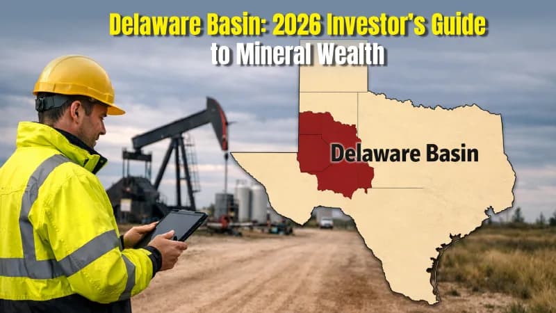
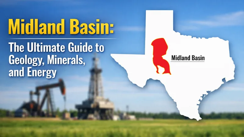
In order to have a feel of the Midland Basin, you have to zoom out first. It comprises the eastern half of the greater Permian Basin. Suppose we have a huge shell of a walnut, which is cut in half. The western half is the Delaware Basin (which extends into New Mexico) and the eastern half is the Midland Basin, which is a True Texan, and which remains entirely within the lines of the state.
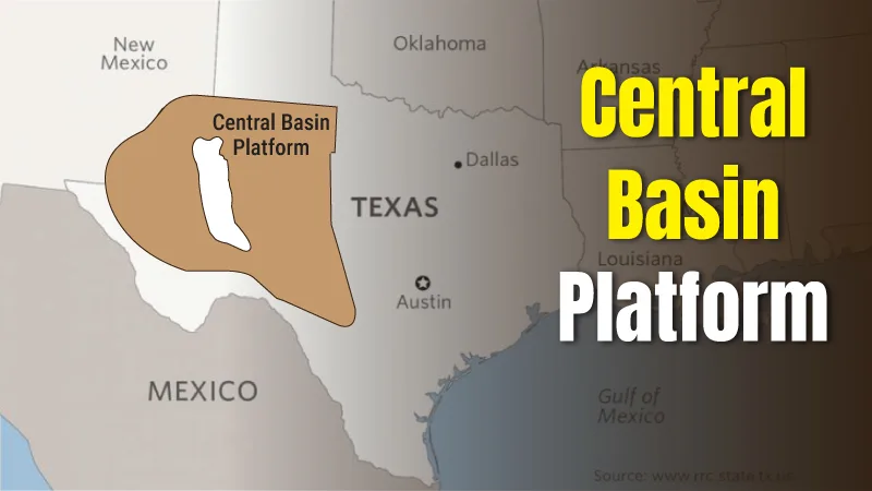
A huge underground ridge of limestone called the Central Basin Platform divides the two basins, and the Eastern Shelf forms the basin's eastern edge. The Midland Basin spans roughly 14,000 square miles, extending from Lynn County in the north down to Crockett County in the south. Within that footprint, the "sweet spots" sit in a handful of powerhouse counties:
- Midland and Martin: The play often looks at these two as the crown jewels of the play.
- Howard and Glasscock: The Wolfcamp shale is especially thick on its eastern frontier.
- Upton and Reagan: Where the Spraberry and Wolfcamp intersect in the south.
“Whether you are looking at it from a legal rights perspective or a purely geological one, understanding this basin is essential to understanding the modern American energy landscape.”
How a Prehistoric Sea Became an Oil Powerhouse
The Midland Basin didn't start as a desert. Hundreds of millions of years ago, during the Paleozoic Era, this area was a deep marine trough. It was part of the Tobosa Basin, a broad depression that collected sediment for eons.
The real transformation happened during the Pennsylvanian and Permian periods (roughly 300 to 250 million years ago). Continental plates collided, creating the Ancestral Rocky Mountains and the Marathon-Ouachita fold belt to the south. This tectonic "squeeze" warped the earth, pushing up the Central Basin Platform and dropping the Midland Basin floor.
As the basin sank, it became a perfect trap. Over millions of years, tiny marine organisms died and settled into the stagnant, oxygen-poor depths. Because there was no oxygen to break them down, they cooked over time under the heat and pressure of the earth, turning into the organic-rich shales we now call the Wolfcamp and Barnett.
The "Stacked Pay" Revolution
Stacked pay means multiple oil-producing layers exist beneath the same acreage, allowing operators to drill several horizontal wells without acquiring new land.
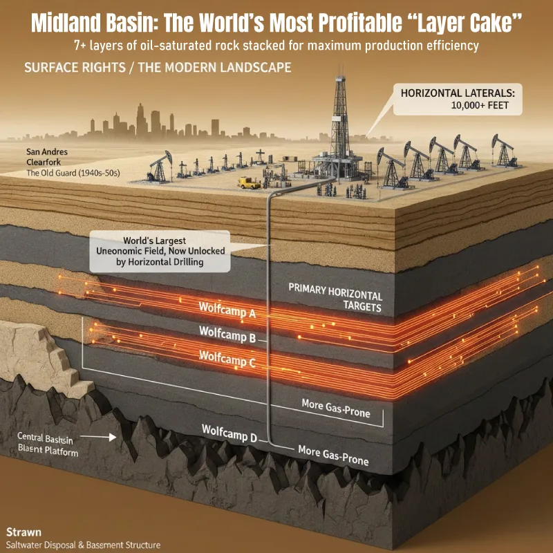
The reason the Midland Basin is so profitable today is a concept called "Stacked Pay". In many oil fields, you have one target zone. In the Midland Basin, you have five, six, or even seven layers of oil-bearing rock stacked on top of each other.
While the Wolfcamp remains the 'heavyweight', the biggest story in 2026 is the emergence of the Midland Barnett Shale. Targeting deeper layers previously overlooked, operators like Occidental and Diamondback are finding that the Barnett in the Midland core produces significantly less water than shallower targets, drastically lowering disposal costs and reducing seismic pressure.
The Spraberry Trend
Located above the Wolfcamp, the Spraberry is a massive interval of silty sandstones. For decades it was known as the "world's largest uneconomic oil field" because the rock was too tight to produce. Today, with horizontal drilling, it is a primary target. Where operators develop the Spraberry and Wolfcamp together — as most now do — the Texas Railroad Commission calls the combined interval the "Wolfberry."
The Wolfcamp Shale
This is the heavyweight champion of the basin. For mineral owners, the Wolfcamp is important because it supports long-term drilling activity and sustained royalty potential. It is divided into four "benches":
- Wolfcamp A and B: The most popular targets for horizontal wells, known for high oil cuts.
- Wolfcamp C and D: Generally deeper and more gas-prone but still highly valuable.
The San Andres and Clearfork
These are shallower carbonate (limestone and dolomite) layers. They were the "old guard" of the basin, providing the vertical production that built the Texas oil industry in the 1940s and 50s.
The Deep Horizons
Below the Wolfcamp lie the Strawn, Atoka, and Ellenburger formations. While less of a focus for "shale" operators, these deeper zones are critical for understanding the basin's basement structure and, occasionally, for saltwater disposal.
Identify which stacked formations are being developed under your acreage and monitor new permits occurring with MineralView!
Mineral Rights and Legal Landscapes in West Texas
In Texas, mineral rights ownership usually controls how and when oil and gas development occurs. In the Midland Basin, decades of drilling have split ownership into many small fractional interests. Modern horizontal wells can now cross multiple tracts, affecting several mineral owners at once.
Effective January 1, 2026, a new Texas law (HB 3159) provides a temporary severance tax exemption for hydrocarbons produced from 'restimulation wells'. To qualify, a previously inactive well must receive a new hydraulic fracturing treatment; successful applicants are exempt from the standard 4.6% oil tax for up to 36 months or until $750,000 in tax is saved. This is a critical value-add for mineral owners in mature Midland Basin sections
This implies that in case you own the minerals, you usually can use the surface as a way of accessing them. This gives a complicated network of legal arrangements in the Midland Basin.
Due to the maturity of the basin, numerous mineral rights have been separated from the surface rights in 80 or 90 years. There may be dozens of fractional owners to one 640-acre piece in Martin County. To a mineral owner in the Midland Basin, value will now lie not in primary production but in the horizontal laterals, which can extend two miles or more across several sections.
Audit your Midland Basin assets and track new horizontal activity happening there with Mineral View Map feature.!
Beyond Oil: The Evaporite Resources (Salt and Potash)
While oil gets the headlines, the Midland Basin is also a massive chemical warehouse. As the ancient Permian seas finally dried up, they left behind gargantuan deposits of salt and minerals, known as evaporites.
The Salado Formation is the most famous. It contains massive beds of halite (rock salt) and potash. While the most intensive potash mining happens just across the border in New Mexico (the Carlsbad district), the Midland Basin's salt layers are vital for the following:
- Brine Production: Used in drilling fluids.
- Storage Caverns: Salt is impermeable. This makes it perfect for leaching out giant underground caverns to store Natural Gas Liquids (NGLs) or crude oil.
- Industrial Feedstock: Supporting the massive Texas chemical industry along the Gulf Coast.
Seismicity and the Modern Operational Challenge
If you look at a map of the Midland Basin today, you’ll see something geologists didn't talk about twenty years ago: fault lines. We now know there are nearly 800 basement-rooted faults in the basin.
Between 2017 and 2024, the region saw a spike in earthquakes (seismicity). Experts and regulators at the Texas Railroad Commission (RRC) have linked this not to hydraulic fracturing itself, but to the disposal of produced water.
When you pump oil, you also pump up ancient "produced" saltwater. Operators have historically injected this water back into deep layers like the Ellenburger. However, this increased the pore pressure on those ancient faults, causing them to slip.
Seismic Response Areas (SRAs):
The RRC has now established zones in the Midland Basin where disposal is strictly limited to prevent these "induced" quakes.
Water Recycling:
To combat this, the industry is moving toward "circular" water management—cleaning produced water and using it for the next "frac" job instead of burying it.
These seismic regulations typically do not change mineral ownership or royalty. They can, however, influence where and how quickly new wells are drilled. The Railroad Commission (RRC) finalized a historic overhaul of oilfield waste rules (Statewide Rule 8) that went into effect on July 1, 2025.
For the first time, operators are required to register the exact location of earthen waste pits and provide enhanced financial security (bonds) for produced water recycling facilities. As of January 1, 2026, all existing recycling pits must be registered under these new stringent standards to mitigate environmental risk and induced seismicity.
The Economics: Why the Midland Basin Wins
Why does capital keep flowing to the Midland Basin through every price cycle? It comes down to break-even costs. The greater Permian Basin now accounts for nearly 40% of all U.S. oil production and nearly 15% of its natural gas, according to Federal Reserve Bank of Dallas figures published by the Texas Railroad Commission — and the Midland Basin is its Texas engine. Lower drilling costs help explain why Midland Basin activity often continues even during oil price downturns. For mineral owners, this often means longer-lasting production compared to higher-cost basins.
Due to the thickness of the oil-bearing rocks and the existence of infrastructure (pipelines, refineries, and crews), drilling a well in the Midland Basin is one of the cheapest in the world.
As of early 2026, Tier 1 breakeven costs in the Midland Basin have shifted to approximately $55–$61 per barrel due to sustained labor and equipment inflation. While still the most competitive in the U.S., the basin is now an 'efficiency play' where profitability is maintained through longer laterals rather than just low service costs.
The U.S. Geological Survey has put a number on what is left. In November 2016 it assessed the Wolfcamp shale in the Midland Basin at a mean of 20 billion barrels of undiscovered, technically recoverable oil, along with 16 trillion cubic feet of natural gas and 1.6 billion barrels of natural gas liquids. At the time it was the largest continuous oil accumulation the USGS had ever assessed in the United States. This is not a field in its final act — it is a field in its second.
The Evolution of Drilling Technology
The Midland Basin's success is a triumph of engineering. In the 1920s, the "Big Lake" discovery was a fluke found by drilling a vertical hole and hoping for the best. Today, the process is surgical.
- Long-Lateral Drilling:
It is now common to see wells with "laterals" (the horizontal part) exceeding 10,000 to 15,000 feet.
- Pad Drilling:
Instead of moving a rig for every well, operators put 10 or 20 wellheads on a single "pad," drilling them all in a row like a factory line. This shrinks the surface footprint and saves millions in costs.
- Simul-Fracs:
New technology allows crews to "frac" two wells at the exact same time, cutting the time to bring a lease into production by weeks.
Regional Production Trends and Data Analysis
Modern oil and gas data reveals that the Permian Basin covers a vast area spanning West Texas and southeastern New Mexico, though the Midland Basin remains its primary Texas engine.
According to the Texas State Historical Association, the region has transitioned from early 20th-century exploration to a high-tech manufacturing model. We have seen a significant increase in natural gas production alongside record-breaking oil production, with output often measured in millions of boe (barrels of oil equivalent) per day.
At present, advanced mapping of the Wolfcamp formation allows operators to target Permian-aged rock with surgical precision. This development is most aggressive in the "core" counties; while Howard county and Reagan county lead in lateral efficiency, activity in Mitchell county continues to define the basin’s eastern edge.
In the southern part of the basin, the vertical stacking of reservoirs ensures that the natural resources here remain the most competitive in the global market. Despite a maturing landscape, the integration of new well productivity data suggests that the Midland Basin’s role as a global energy leader is far from over.
Conclusion: An Authoritative Look at Texas’s Subsurface Powerhouse
The Midland Basin is not only a geologic province but also the foundation of Texas' economy and energy security in the world. Since the early tectonic movements that formed the Tobosa Basin up to the current day's so-called shale gale, this area is very resilient.
Its distinctive geology of stacking can be used to get several layers of production and hence a single acre of land can be made worth far more than any other oil field in the world. To the people of West Texas, the Midland Basin is employment and home.
It is a complicated and yet valuable asset to the mineral owner and must be carefully treated both legally and geologically. And to the world, it is a source of consistent supply of hydrocarbons and other vital minerals such as salt and potash.
With the technology ever changing, longer laterals, and more efficient water reuse, the Midland Basin would certainly be at the forefront again, and the story of the Permian would certainly be written, one rock layer at a time. For mineral owners, knowing how active your county is within the Midland Basin provides valuable context beyond a single well. Tracking production trends and drilling patterns helps owners better understand the long-term direction of their minerals.