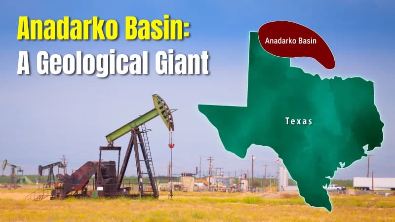
What many people imagine about the American heartland is the never-ending rolling plains and wheat lands but there is something below the surface of the Texas Panhandle and Western Oklahoma that is a geology giant. Peel back the earth, and there is a huge, bowl-shaped hole, stuffed with miles of prehistoric rock, pressurized gas and black gold. It is the Anadarko Basin, one of the most important energy regions in North America and a basin that directly affects mineral owners across Texas and Oklahoma.
The Anadarko "Super Basin"
- Size: Over 50,000 square miles across TX, OK, and KS.
- Depth: Reaches over 40,000 feet—one of the deepest in North America.
- Production: Billions of barrels of oil and trillions of cubic feet of gas.
- Diversity: Global source for Helium and the only domestic source of Iodine.
The Anadarko Basin has been the foundation of American energy independence for more than one hundred years. It is not a field of oil wells but rather a " Super Basin," one of those rare formations on the earth where the rocks are so thick and the material so rich that it appears to be running indefinitely. This basin is something every mineral rights owner in the Texas Panhandle and western Oklahoma should understand because its activity directly influences well development, production levels, and long-term royalty income.
In this guide, we break down how the Anadarko Basin formed, why operators continue to invest in it, and what this activity means for mineral owners today.
Key Takeaways
A Geological Giant:
Spanning 50,000 square miles, it is one of the deepest sedimentary basins in North America, with rock layers plunging over 40,000 feet.
The "Super Basin" Status:
It has produced billions of barrels of oil and trillions of cubic feet of gas, with massive unconventional plays like SCOOP and STACK leading modern production.
Beyond Oil & Gas:
The basin is a critical global source for Helium and is the only commercial producer of Iodine in the United States.
Record-Breaking Depths:
Home to the Bertha Rogers No. 1, a well that once touched the "limits of the earth" at over 31,000 feet.
Economic Anchor:
The basin’s performance influences drilling activity, production levels, and long-term development decisions that directly impact mineral owners’ royalty income.
The Anatomy of the Anadarko Basin: Depth and Geology
To understand the Anadarko Basin, you have to think in three dimensions. Geologists describe it as an " asymmetric" basin. Imagine a bowl where one side is shallow (the northern shelf in Kansas) and the other side drops off a cliff (the deep southern portion near the Wichita Mountains in Oklahoma).
The Power of the Aulacogen
The basin began as a ‘ failed rift,’ known to geologists as an aulacogen. Hundreds of millions of years ago, the earth tried to pull apart but stopped. This created a massive hole that filled with organic-rich sediments for over 250 million years.
Stratigraphic Layers: The "Layer Cake" of Wealth
The basin isn't just one reservoir; it is a " stacked" system. This means an operator can drill one hole and pass through multiple productive zones:
- The Arbuckle Group: Ancient carbonates at the very bottom.
- The Woodford Shale: The "Mother Lode" source rock. It’s a dark, organic-rich shale that generated most of the oil in the region.
- The Pennsylvanian Sands: This includes the famous Granite Wash, a thick sequence of sand and gravel eroded from the mountains and trapped in the deep basin.
| Location | Sedimentary Thickness | Geological Character |
|---|---|---|
| Northern Flank (Kansas) | 2,000 – 5,000 ft | Shallow, conventional gas targets. |
| Central Basin (Oklahoma) | 15,000 – 25,000 ft | The heart of the STACK play. |
| Southern Deep (TX/OK Border) | 30,000 – 40,000+ ft | Extreme pressure, ultra-deep gas. |
Iconic Fields and the Hunt for "Deep Gas"
The Anadarko Basin is a history of human beings pushing machines to the brink of destruction. The mid-20th century saw the Deep Anadarko being the frontier of the oil world.
The Hugoton-Panhandle Field
The Hugoton is a legend extending westward in the Texas Panhandle to Kansas. It was the largest natural gas field in North America in decades. It was a source of cheap energy to drive the post-WWII American industrial boom.
Breaking the Barricades: The 31,000–Foot Well
The GHK Company drilled the Bertha Rogers No. 1 in Beckham County, Oklahoma, in 1974. They were searching gas reserves deeper than ever before. They struck 31,441 feet, almost six miles below.
The pressure there was so high (more than 24,000 psi) and the heat was so high that they actually came across molten sulfur. Though it was not a huge producer, it demonstrated the Anadarko Basin was where technology and ambition had come together.
Iodine and Helium: Industrial Minerals
Many people are unaware that materials like iodine used in medical treatments or helium used in industry are produced alongside natural gas in the Anadarko Basin.
- Iodine: X-ray contrast media and pharmaceuticals heavily require the Iodine element; that element has only a domestic source in the Woodward area of Oklahoma.
- Helium: The gas is trapped between natural gas and helium, containing, as a result, a basin of unique basement rocks, which makes this area a strategic national reserve.
The Unconventional Revolution: SCOOP and STACK
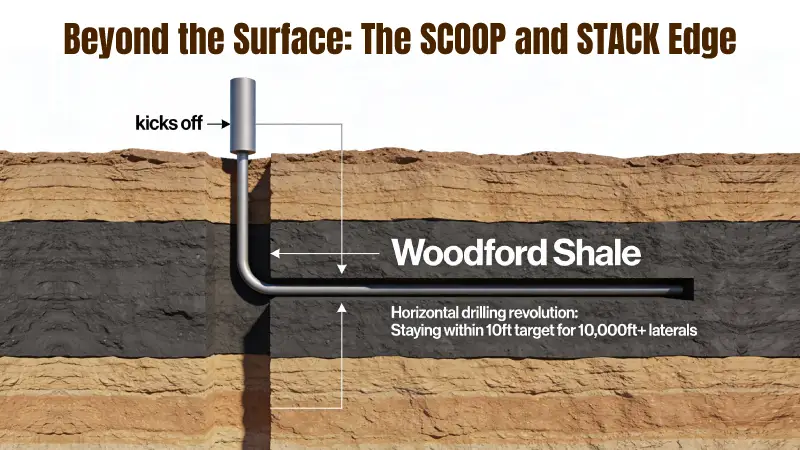
For a long time, the "tight" rocks of the Anadarko were considered "trash." You could see the gas on the logs, but it wouldn't flow to the wellbore. That changed with the perfection of horizontal drilling and hydraulic fracturing (fracking). This birthed the modern "alphabet soup" of plays that dominate the Anadarko Basin today.
Woodford Shale
Woodford is the foundation of everything. It is a Devonian-age shale that is incredibly rich in Total Organic Carbon (TOC). In the modern era, operators don't just "pass through" the Woodford; they turn the drill bit 90 degrees and stay inside it for two or three miles.
Understanding the SCOOP
SCOOP stands for South Central Oklahoma Oil Province. This play targets the Woodford and Springer formations. It is known for producing "liquids-rich" gas—meaning the gas comes out with high-value components like ethane, propane, and butane alongside light sweet crude oil.
Understanding the STACK
STACK stands for Sooner Trend, Anadarko Canadian and Kingfisher (referring to the counties it covers). The STACK is famous because it is "stacked." An operator might target the Meramec formation and then drill another well right below it into the Osage or the Woodford. This "pad drilling" allows for massive economies of scale.
Mineral Rights and the Business of the Basin
When you own mineral rights in the Anadarko Basin, you are the custodian of a long-term energy asset that can generate royalties for decades when managed and monitored properly. The term "severed minerals" is used in Texas and Oklahoma, whereby the top may be owned by one individual and the gas and oil under it by another.
The Role of the Regulator
The Railroad Commission of Texas (RRC) oversees production under the major 2025 Chapter 4 rule overhaul. Effective July 1, 2025, these rules modernized waste management for the first time in 40 years, introducing strict e-manifesting requirements for oilfield waste and new standards for produced water recycling pits to protect Texas groundwater.
One of the most important legal concepts for mineral owners in the Anadarko Basin is pooling, which allows operators to combine multiple mineral interests to develop a well efficiently.
Concentration and Effectiveness
These days, the basin is occupied by the "Super Independents" such as Devon Energy, Continental Resources and EOG Resources. Such firms have abandoned the wildcatting of the 1970s. Today, operators treat the Anadarko Basin more like a manufacturing operation, using data analytics and advanced seismic imaging to plan wells with precision.
Why the Anadarko Basin Matters to Mineral Owners
Energy as an Inflation Bellwether
Energy production directly affects mineral owners because it determines drilling activity, operating budgets, and long-term production stability. When the Anadarko Basin sees a spike in drilling costs or a drop in production, it ripples through the economy. High energy prices are a primary driver of inflation. Historically, the Anadarko Basin’s gas output has been a primary driver of Henry Hub pricing, making it a focal point for hedge funds and commodity traders tracking energy inflation.
The Future of the Anadarko: Carbon Capture and Beyond
Is the Anadarko Basin still relevant for mineral owners today? Far from it. The basin is entering a "Third Act."
Natural Gas as a "Bridge Fuel"
As the world looks to reduce carbon emissions, the high-quality natural gas from Anadarko is seen as a "cleaner" alternative to coal for power generation. Furthermore, the basin's proximity to the Gulf Coast makes it a primary supplier for Liquefied Natural Gas (LNG) exports to Europe and Asia.
Carbon Sequestration
The same geological traps that held gas for millions of years are now being studied for Carbon Capture and Storage (CCS). The Anadarko Basin could eventually become a "carbon sink," where CO₂ is pumped back into depleted reservoirs, helping to balance the energy needs of the future with environmental goals. For mineral owners, these emerging uses may create future leasing opportunities beyond traditional oil and gas development.
Legacy Fields and Future Growth
While much of the oil and gas industry focuses on the Permian Basin, west central Oklahoma is seeing a steady comeback. Traditional gas production in places like the Union City Field and West Edmond Field is being reimagined as companies target unconventional reservoirs that were once too difficult to drill. This shift is driven by better economics and a greater understanding of the siltstones and hydrocarbons deposited in the deeper parts of the basin.
Today, a lot of drilling activity occurs on the western flanks, where the organic source rock is highly productive. Beyond energy, the basin is a major producer of iodine; in fact, it is the only commercial source of iodine in the U.S. Notably, under the RRC’s 2025 Rule §3.82, the basin is now a primary target for brine mining of Lithium, with the Commission establishing a clear regulatory framework to extract these 'green' minerals alongside traditional hydrocarbons. Producing these minerals alongside oil and gas ensures the basin remains a commercial source of essential materials every day, making it a vital part of American exploration.
Final Words: The Enduring Legacy of the Anadarko
The Anadarko Basin is a place on a map, and it is also the geological treasure of North America as well as the inventive power of the artisans that populate it.
This basin keeps reinventing itself, as it did from its record-breaking depths of the 1970s to its high-tech horizontal superpad of the present day. It is still one of the pillars of the world energy market, affecting global energy security at a time when U.S. LNG exports are hitting record highs of 18 Bcf/d, directly linking Anadarko Basin production to the heating bills of Europe and Asia.
For mineral owners, understanding the Anadarko Basin is not about speculation—it is about knowing what is happening beneath your land, who is developing it, and how that activity affects your royalties over time.
How Mineral Owners Use This Knowledge
Mineral View helps mineral owners track wells, monitor operator activity, and understand production trends across basins like the Anadarko—all in one place.
If you own minerals in Texas or Oklahoma, staying informed is the first step to protecting long-term value.